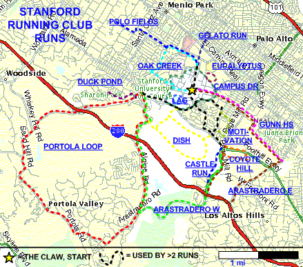
| |
|
|
Click on the blue run names on the map below for
their descriptions or
use the table underneath.

(Click here
for an interactive map, where one can do a virtual run of any of the courses
above)
| Run (Click for details/pics) |
Mi. |
Run |
| Treks
usually starting from the Claw... |
|
Dish loop |
3.3 loop |
Very Hilly, Paved |
|
Oak Creek |
3.75 |
Flat, Paved and dirt |
|
Polo Fields |
6 |
Flat, Paved |
|
Gunn High School |
6 |
Gradual inclines, Paved |
| Alpine to the Dish |
5 |
Very Hilly, Paved, Cows |
|
Duck Pond |
5-5.5 |
Flat with rolling hills, Paved |
| Portola Run |
11.8 loop |
Long inclines, Paved with dirt trails |
| Arastradero West |
9 |
Inclined with rolling hills, Paved and dirt |
| Arastradero East |
9 |
Inclined with rolling hills, Paved |
| Castle Run |
5.5 |
Flat with a nice shaded, carless stretch |
| Coyote Hill |
5.3 |
One hill, unshaded, horses run with you |
| Motivation |
3.25 |
Nice view, little work. (This is
the one you're looking for.) |
| Gelato Run |
2.75 |
Through Palo Alto. (Ice Cream Run!) |
|
Go running without ever leaving campus... |
|
Campus Drive |
4.0 (outside)
3.8 (inside) |
Gradual inclines, Paved and dirt |
|
Lake Lag |
0.9 loop |
Flat, Dirt |
| Galvez Eucalyptus Grove |
1-2 loop |
Flat, mulch paths |
| Stanford Stadium |
400m |
Old track, but runnable |
| Stanford Track |
400m |
Nice, but odd hours |
|